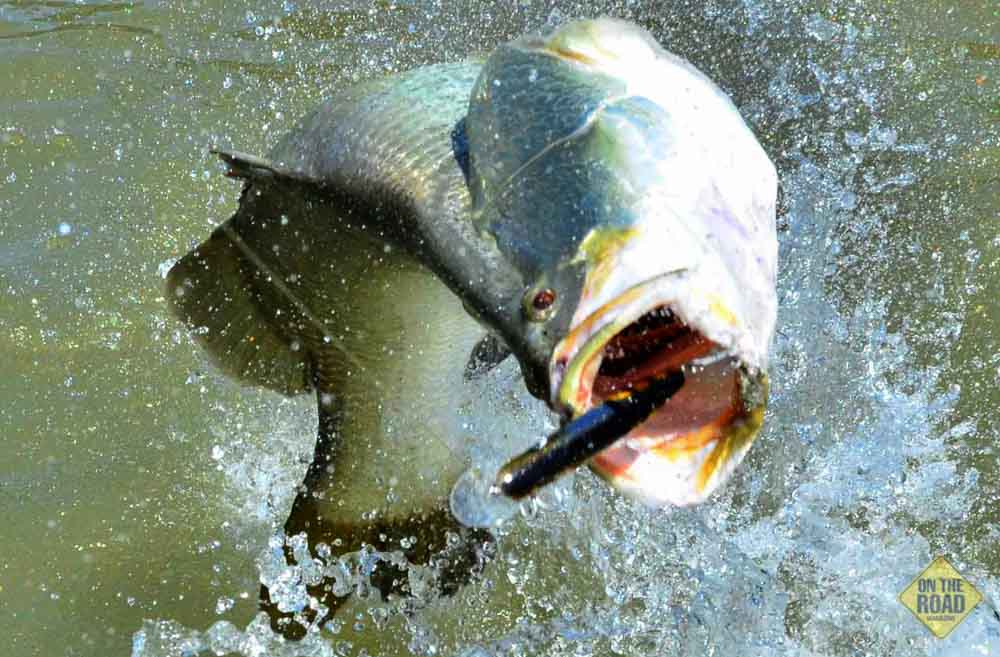
The carrot that dangles at the end of the line is barramundi. At least that’s how it is for many travelling anglers hitting the northern highways across the Top End. The tug is the drug, but it is a magical two-word phrase that keeps us going: Road Trip.
And for those who have a yearning for fish and travel, the road that links Lake Argyle to Broome, across the southern edge of the Kimberley, has much to offer. Companionable and limitless, this bitumen track starts near the end of the Victoria Highway before merging to the Great Northern Highway and snaking its way across a vast, empty space that is the Kimberley.

For travelling anglers, road trips are about memories, not just places visited, but the sights of the road, and the fishing. Driving the highway from Lake Argyle to Broome, you are struck by a tapestry of colour: soil ochres that change with the light from pale yellow to orange in the mornings, to a crimson glow late in the day. There are hundreds of thousands of acres of brittle, yellowing spinifex, spindly mulga and small trees pockmarking broad acres that abut the long escarpments running above talus ridges.
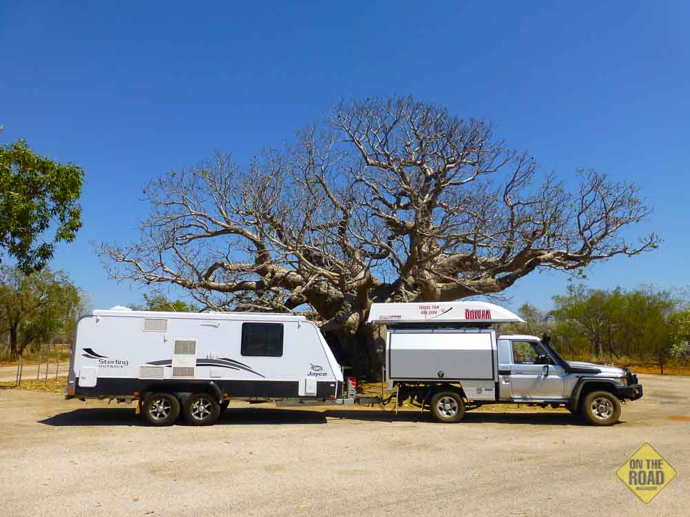
In places, sparse woodland emerges, and there is always an occasional boab tree for colour. Boab trees can grow to 15m high, and have a trunk circumference of 20m. While it is the silhouettes of boabs, with their immense, swollen trunks, most travellers remember, there is much more to see.
Along some stretches of highway, the road is built up above the surrounding land, explaining the floodwater measurement signs that seem so out of place in this desiccated terrain. As you pass above isolated billabongs, nestled down in deep trenches that seem to go nowhere, you have to wonder how deep these waterholes are, given that they haven’t evaporated in this hot, cloudless environment.
The lifeblood of the Kimberley are mighty rivers, like the Victoria, Ord and Fitzroy. During the Wet, these rivers merge to create enormous inland seas. Such is the volume of run-off that long stretches of highway are several metres above the natural floodplain, and cambered to allow for high flow water run-off.
It is difficult not to feel isolation as you drive across the Kimberley. Even though there are other campers and trucks, road travel isn’t what you call a traffic jam. This is a vast, wild, unforgiving, and magnificent country, and I love it.
LAKE ARGYLE
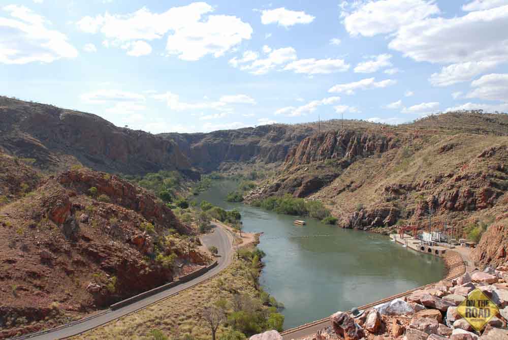
Lake Argyle, about 70km west of Kununurra, is Australia‘s largest artificial lake by volume. At maximum flood level, the waters spread out over more than 2,072 sq.km, and when this happens Lake Argyle is bigger than Victoria’s Port Phillip Bay (1930 sq. km).
Part of the Ord River Irrigation Scheme, there are more than 70 islands and, apart from the area of Coolabah Pocket adjacent to the dam wall, the lake is full of dead trees, although these are underwater.
The primary inflow is the Ord River, while the Bow River and many other smaller creeks also flow into the dam. Due to its size, Lake Argyle is a difficult place to know where to start fishing, but there are 26 species of native fish, including barramundi, southern saratoga, archer fish, forktail catfish, mouth almighty, long tom, bony bream and sleepy cod. The biggest fish in the lake is silver cobbler or shovel nosed catfish. Regarded as fine table fare, these giant catfish can grow to about 1.5m and weigh up to 40kg. As well, the lake is home to an estimated 25,000 freshwater crocodiles.
KUNUNURRA
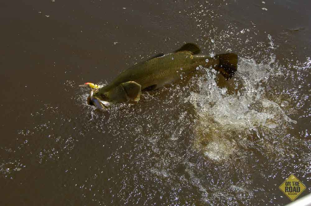
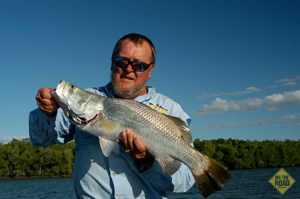
Kununurra is an ideal staging post for fishing Lake Argyle and surrounding waters. There are many safe places to fish, but it’s wise to call the Kununurra Visitor Centre for the latest road conditions. The most sought after fish is barramundi, and all the local waterways have them. Be aware that barramundi have a legal size limit of between 55–80cm for the Lower Ord and Fitzroy River systems. In the Lower Ord and Broome areas, a possession limit of one barramundi per angler applies. Elsewhere in WA, a bag limit of two barramundi per person applies.
Some of the better-known locations on the Ord River, and these require a 4WD, are:
- Ivanhoe Crossing: A causeway built over the Ord River.
- Buttons Crossing: Along Parry Creek Rd, camping is permitted.
- Mambi Island: Along Parry Creek Rd. There is a boat ramp, and camping is permitted. This is a popular base for anglers wanting to spend a few days fishing the Ord.
- Skull Rock: Along the Carlton Hill Road.
For access to any of the above mentioned places, check with the Kununurra Visitor Centre before leaving: phone 1800 586 868 or visit www.visitkununurra.com
WYNDHAM
Wyndham, Western Australia’s most northerly town, is about as isolated as any town in Australia can be. It is situated on the southern tidal waters of the Cambridge Gulf where the King, Pentecost, Durack, Forest and Ord Rivers meet. To get your bearings, take a drive to Five Rivers Lookout atop Mount Bastian. It overlooks the town and port, tidal marshlands plus the five river mouths.
Wyndham is the northern gateway to the Gibb River Road, Kalumburu and Derby. The port has a couple of mooring jetties that are popular with anglers. The best fishing is in the rivers; some of these have already been mentioned.
Pentecost River is a noted waterway for barramundi. Pentecost Crossing, where the Gibb River Road crosses over the Pentecost River, is a popular fishing destination. Southwest of Wyndham, the fishing is in the freshwater crossing of a small stream at the head of Cambridge Gulf.
For those without 4WD vehicles, the following are easy to access:
Lake Kununurra, is where you can fish along the banks of Lilly Creek Lagoon for some silver cobbler and bream, or head out in a boat further onto Lake Kununurra. The Spillway, en route to Lake Argyle from Kununurra, Spillway Creek is noted for producing quality barramundi fishing.
FITZROY CROSSING
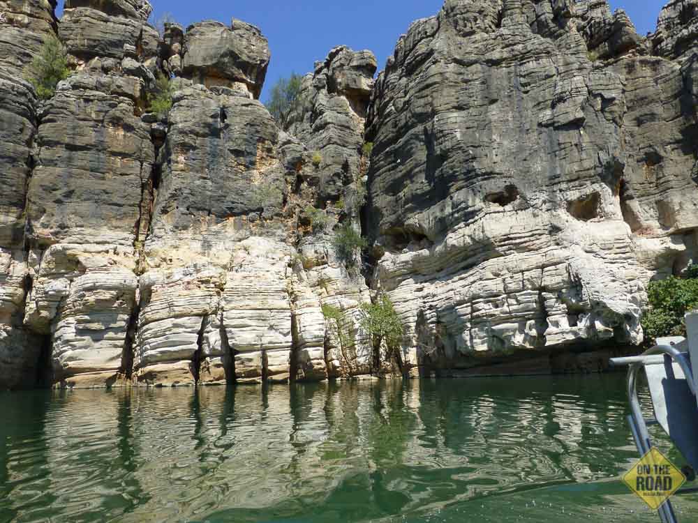
Driving the Great Northern Highway from Kununurra, you drive through Halls Creek and then on to Fitzroy Crossing. As the name suggests, the main watercourse is the Fitzroy River, which produces barramundi, sooty grunter and mangrove jack. The best-known attraction is Geikie Gorge, a tourist hotspot. From April to November, private boats and canoes may access the gorge before 7am or after 4.30pm, you must notify rangers before launching your boat. Fishing is allowed above and below the gorge. When I visited, nobody could tell me whether I was allowed to fish in the gorge, and given the boating restrictions, I suggest it would be better to fish elsewhere; there are enough options. There are many access points to the Fitzroy River; however, the most popular are further west near the Willare Roadhouse.
DERBY
Derby in the West Kimberley has Australia’s highest tides: A rise and fall of 11.8m. The port has a large wharf and this is a popular fishing destination. Even though anglers will be found fishing the wharf at any time of tide, the tidal run is so strong that fishing is best pursued near the top or bottom of the tide as the current slows. Fish that are caught from the jetty include threadfin salmon, jewfish, golden grunter, sharks and catfish. Close to shore, the bank is lined with mangroves, and as the tide drops, anglers fish the run-off drains for barramundi, or seek out mud crabs.
Derby is the gateway to the Buccaneer Archipelago in King Sound. The full range of northern reef species is found including fingermark bream, coral trout, mangrove jack, bluebone and barramundi. The only way to fish the archipelago is from a boat. Given the enormous tidal range, King Sound is treacherous water, and the safest way to venture to this area is with a local charter boat operator.
The May River, about 40km northeast of Derby on the Gibb River Road, offers excellent barramundi fishing, but you need to contact Meda Station for permission to access areas on the station.
The main river flowing into Derby is the Fitzroy. During the Wet, this river swells to become one of the world’s biggest rivers with a 90,000 sq. km catchment area. Access to the river mouth is only possible from the south bank due to Noogoora burr quarantine regulations on the north bank.
Derby has a large caravan and camping park, and a couple of motels.
WILLARE ROADHOUSE
Between Broome and the Ord River, the road crosses a plateau over 500m high. Flanked by the Durack Range with peaks to 900m, to the south is one of the world’s largest deserts. Between the Cape Leveque turnoff and Halls Creek, the country opens. Driving from Broome to Derby on the Great Northern Highway, you cross Willare Bridge on the Fitzroy River before arriving at Willare Roadhouse. The deeper pools near the bridge offer fishing opportunities for barramundi and cherabin, the latter working well for bait and a feed.
Access to fishing spots along the Fitzroy River is via signposted access roads, and the best source of information about these roads, and access, is Willare Roadhouse: (08) 9191 4775. Many anglers who fish the Fitzroy River prefer to stay at the roadhouse.
Popular fishing spots are Willems Pool, Langi Crossing, and Telegraph Pool. To get to Willems Pool, turn off after you cross the Fitzroy River. There is shady camping and permanent fresh water. The turnoff to Langi Crossing and Telegraph Pool is 140km from Broome. It is a dirt track and you will need a 4WD. Langi is the first pool you will come across; turn right after the second gate and look for the old bridge. The second pool is Telegraph Pool. To get there continue after the second gate without turning off, and follow the track until you see the old telegraph pole and a big pool before turning off. Both pools have permanent saltwater and produce barramundi. Boat launching can be a struggle at Telegraph Pool as the sand is soft and the bank steep. These are all on Yeeda Station, and although open to the public, the station owners need to be notified before you arrive on (08) 9191 4766. Camping is allowed for a two day maximum on the station.
CAPE LEVEQUE
Cape Leveque is north of Broome, the turn-off about 10 minutes east on the Great Northern Highway going to Derby. The road is gravel, wide and graded, for about half the drive before changing back to bitumen. It takes about two hours from the turn-off to the top of the Cape at One Arm Point. Be aware there are many areas of the cape off-limits to visitors and require a permit to access. A 4WD vehicle is advisable as the side roads can be soft.
Willie Creek and Barred Creek, and the other northern beaches are accessed off Manari Rd, which you reach via a turn-off from the Cape Leveque Rd. Further along Cape Leveque Rd are Middle Lagoon, and the Hunter Creek at Kooljaman Resort/Cape Leveque.
The easiest fishing area to access is Middle Lagoon. This sheltered waterway features a campground and cabins. The drive in is on a sand road, and takes about 20 min. Beach, rock and boat fishing is available, with boats launched from the beach. Species caught in the lagoon include golden trevally, queenfish, threadfin salmon, blue salmon and reef species.
THE WAY IT WAS
Ron Pearson spent 40 years teaching in the Kimberley at places like Sunday Island (Bardi-Jawi people), Derby, Christmas Creek, Camballin, Cockatoo Island, Fitzroy Crossing (Wanmadjeri people), One Arm Point at Cape Leveque, Kalumburu and LaGrange. I caught up with Ron at Albany, and I asked about the fishing life in that part of the world. Here is what he had to say:
“Living in the Kimberley was really good because I had an unlimited supply of fish on which to try things out,” he explained. “When you only get one hit a week, it’s hard to start sorting out what’s good and what’s bad.
“When I first started to effectively catch fish, it was more in the trevally, queenfish area, and then I spread out from there. Up north, man was a bit silly at times; you’d be fishing for whiting and the golden trevally would go past, and having no will power, you’d naturally catch one.”
Ron confessed that his first barramundi was on a plucked crimson parrot set on a springer on a handline: “Not a political thing to mention,” he said. “And thinking back, it was a wonder I didn’t end up with a little croc on it.”
He talked with affection of the friendships developed with the locals. “The Bardi mob is some of the smartest mob you’re going to come across, and they have a wicked sense of humour.
“My best lessons on flats fishing was joining the Bardi-Jawi boys with their spears on the flats. The Bardi were sea people that had closer touch to the land; the Jawi were the only people I know of that were 100 per cent saltwater, and were spread from the Sunday Islands to Montgomery Reef.”
Ron said he got to know when the fish were coming up, what fish were coming and learned how to see the fish, and get an idea of how the fish were going to behave.
“If you think fly-fishing is hard enough on the flat, you have a dash at getting close enough to hit it with a spear,” he said.
“At Cygnet Bay on Cape Leveque, I had a great relationship with an old fella. When he knew I was coming, he would bring a brand new spear out, put it in the ground at my camp, walk away and leave it there. When I was about to leave, he’d come up to see me again and take the spear. That was ‘my lend’ for the time I was out there.
“I have such a soft spot for the Bardi-Jawi mob that it’s hard to explain; it’s family mob, and I still have some very good mates up there.”
Ron and his wife Margarete return every year, when they can: “We camp at Cygnet Bay, near the pearl farm. It’s a better place for me to launch my boat,” he said.
“When it was a closed pearl farm, I had everything to myself, but now they’ve gone into tourists I’m a little bit lost.
“I first went there in early 1962 and, at that time, schools of mullet were harassed all night by huge trevally. In the same area now I have to go hunting, even for the little trevally.”