Very scenic, offering the opportunity to experience an array of wildlife, natural and historic features and an array of recreational activities
If I had to describe Lake Eildon National Park in a single word it would be diversity. The park, more than any other I have seen (and I’ve been to scores of them across Australia), offers the visitor many different kinds of environment, from rugged mountain ranges to a broad freshwater lake, with easy access to a wide range of opportunities for adventure-based activities. And all of this lies only 150km northeast of Melbourne on the edge of Victoria’s Central Highlands.


The park has been on my bucket list for about 30 years, ever since I travelled through the Murrindindi district on a lightning road trip with a young family during school holidays. It was clearly marked on the map and oh so close, but it may as well have been on the moon because of time constraints and a lack of appropriate camping gear, and we had to pass it by. Fast forward to January 2015 – the kids are all grown up, my wife (Elizabeth) and I are retired and we own a Landcruiser and Kimberley Karavan equipped with everything one could ask for by way of comfort in the bush. As for the itinerary, we had several days to kill on our way to the docks of Port Melbourne, with passage booked on the Spirit of Tasmania for a tour of the beautiful Apple Isle, and our route from home in Hervey Bay practically traced a line through the park, as the crow flies. We were determined not to miss it a second time.
After 1,850 kilometres of near constant travel over three days, we were looking forward to stretching our car-cramped legs on some of the walking tracks in Eildon’s deeply cleft mountain terrain and scenic lake foreshores. Unfortunately, the weather wasn’t great, with intermittent showers dogging us all the way from Wodonga to Alexandra, which we had to pass through on the way to Candlebark Campground in the northern section of the park. As it was about midday, we decided to treat ourselves to lunch at the historic Commercial Hotel and give the rain a chance to blow over so we wouldn’t have to set up camp in the wet.
Originally settled as “Red Gate” during the gold rush of the 1860s, Alexandra straddles a crossroads that connects the local towns of Eildon, Molesworth and Marysville with a direct route to Melbourne via Narbethong and the Yarra Valley. The hotel itself was established in 1866 in the early days of a local gold rush and occupies a prime position on the main street at the crossroads (hence, its original name The Corner Hotel). On entering the dining room, with tables dressed in white linen and a fresh red rose, we were greeted by the friendly hostess, Henri Buckley, who acquired the hotel with her partner, Tim, in 2007. Since that time, they have lovingly restored and upgraded the premises with particular regard for its pedigree and heritage value. After lunch, Henri gave us a guided tour of the main bedrooms, of which they are justly proud, and, had we not already booked and paid for three days at the national park, we could have happily stayed at this hotel. As it was, we were well satisfied with a tasty lunch of crispy-skinned salmon fillet and a generous bowl of wide-ribbon pasta with spicy pork ragout, accompanied by a glass or two from the hotel’s extensive collection of local wines. Thus fortified, it was time for us to move on.
The road is sealed all the way to the national park and, from Haines Saddle at the top of the range, descends a steep and winding course to Candlebark Campground on the shores of Coller Bay. As the road crested the saddle, we could make out through the lingering “mist” the unmistakable landscape of the ridges and folded gullies that comprise the catchment of Lake Eildon. On reaching the campground, we quickly found our site and set up base. Bookings are essential for camping in all sections of the national park and, it has to be said, the online booking process on the Parks Victoria website is fantastic, replete with easy-to-follow instructions, availability calendars, dimensions for all sites, tent/van/camper suitability and a photo of each site.
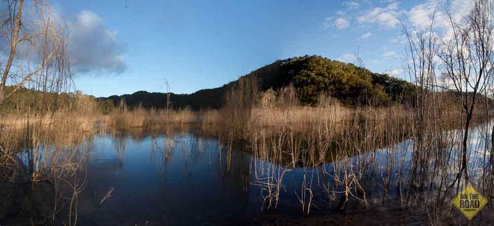
Lake Eildon National Park was proclaimed in 1997 by combining the former Fraser National Park and Eildon State Park, a swathe of about 27,750 hectares stretching from Jamieson to Mansfield and Alexandra. Not only does it provide a superb setting for land and water based activities, but it also protects the catchment and water storage of Lake Eildon. The park’s landscape is characterised by strongly dissected mountainous terrain, which includes eroded remnants of the great Cerberean Caldera, a 27-km diameter volcano that was active about 380 million years ago. Peaks and ridges, some as high as 900 metres, at key locations throughout the park afford panoramic vistas of the lake and surrounding highlands. Large areas of tea tree, herb-rich woodlands and forests of Candlebark, red box and mountain ash cover the slopes from ridge tops to the lake’s shoreline, providing a variety of habitats for a significant number of native animal species, some of them rare and endangered.
The park is also rich in human history. It is believed that many hundreds of the Yauung-Illam-Baluk Aboriginal tribe lived in the upper Goulburn and Delatite River valleys for millennia up to the time of European colonisation. However, they were displaced by the incursion of European pastoralists during the 19th century and the flooding of these valleys by Lake Eildon has inundated many sites of archaeological and cultural significance. Evidence of European activity remains within the park in the form of abandoned mine shafts (which now support some of the largest bat colonies in Victoria), stone fences and stockyards, and infrastructure connected with the development of Lake Eildon.
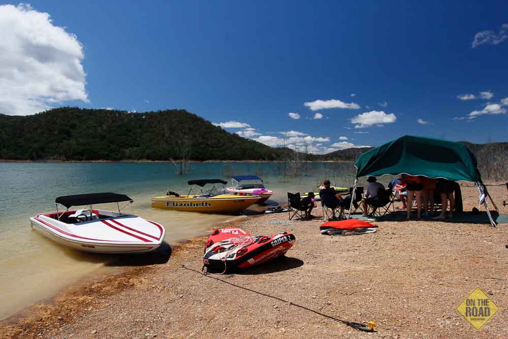
All these natural and man-made features combine to provide a setting of unsurpassed beauty and interest for a wide range of recreational activities – vehicle-based camping in a semi-remote environment, a network of walking tracks and trails for fourwheel driving, mountain biking and trail-bike riding, and easy access to an expansive freshwater lake ideal for swimming, fishing, boating, water-skiing, jet skiing and canoeing. Also, large numbers of Sambar deer inhabit remote sections of the park where hunting (without dogs) is permitted on a seasonal basis.
In the limited time available to us, we decided to split our time here between bushwalking in the Fraser Block (the northern section of the park), sightseeing around the town of Eildon and fourwheel driving in the Jerusalem Block (or southern section of the park). Fortunately, the weather gods were smiling once again and we had several days of uninterrupted sunshine in which to enjoy all these activities.
On day one, we tackled a couple of trails that we combined into one trek, which was not very long (6.5km in total) but was an interesting mix of grades ranging from easy to SAS. A short and scenic drive from our Candlebark camp delivered us to the start of the first leg, the Perfect Cure Creek Nature Trail. (We never did find out the origin or meaning of the creek’s rather curious name but assume that the “perfect cure” had something to do with the discovery of gold in the surrounding hills.) The nature trail was an easy stroll through woodland interspersed with open fields, clearings remaining from early pastoral activities, carpeted ankle-deep with a kind of wild thyme that bore stems of pale lilac flowers that emitted a herbal fragrance when trodden under foot.
As the trail ascended the gully, it carved a tunnel through thick stands of tea tree and silver wattle, sprouting from beds of bright green moss, all vigorously reclaiming the pastures that once comprised the homestead of the Stone family until the 1960s. Another of the valley’s farmers, John Merlo, is said to have discovered a 5 oz. (142g) gold nugget in the section of creek adjacent to the trail – a lucky find as most of the gold in the district was hard won by digging it from rock seams and several mine shafts are featured along this walk. Shadowing the creek, the trail wound beneath several gigantic specimens of Blue Gum and Swamp Gum before entering an area of uncleared natural bushland forested with handsome Red Box, Broad Leaf Peppermint and Candlebark Gums. A glade overlooking the creek was furnished with a rough-hewn log seat to provide walkers with a place of rest and quiet contemplation of the bushland surroundings. We availed ourselves of this for a few moments and it was just as well, for a short distance beyond the glade the trail rejoined the Keg Spur Track and the trek began in earnest.
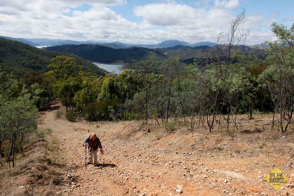
For the next kilometre, this fourwheel driving track rose dramatically and there was not much conversation as we huffed and puffed our way up its slippery, rain-guttered slope to High Camp, a three-way junction at the top of the ridge. What little breath we had left was quickly taken away by the magnificent 360-degree view of the surrounding valleys and the aquamarine lake nestled snugly among their many folds. Clearly visible, too, was the next stage of our hike, Blowhard Spur Track, as it snaked its gravelly way along the ridge to the southeast, hidden intermittently by the eucalypt forest that blanketed the spur and its flanks all the way to the lake’s shoreline far below. For the most part, this track was reasonably level – after all, we had already reached the highest altitude of the park in Fraser Block – but here and there Blowhard dipped then rose in a couple of short, sharp ascents that would have challenged even a fourwheel drive vehicle and obviously gave the track its name.
This rollercoaster ramble continued for a further kilometre, along which we were treated to some of the finest panoramas to be found in the park, clearly viewable through gaps in the forest and thick tea tree scrub that crowded in on both sides of the track. Soon, we came to another junction at a pinnacle where the Merlo Lookout Track left Blowhard and plunged steeply through the forest to the shore of Coller Bay, at a point roughly opposite Candlebark camp, and the road leading back to the carpark. We opted for this route rather than continuing on Blowhard to the end of the spur at Cook Point, which would have added another 5km and 3 hours to our journey so far. The alternate path descended sharply from the ridge and occasionally broke free of the trees and thick scrub that hemmed us in to reveal the shining lake looming ever nearer and bluer from each successive vantage point. Eventually, the track disgorged us at Merlo’s Lookout, so called because it overlooks the spot, inundated by the lake in 1956, where John Merlo built his house in 1882 and cultivated a vineyard that yielded abundant grapes and high quality wine. From here the road was an easy stroll back to the car, then camp for lunch.
By now the day was bright and balmy, with a light breeze ruffling the lake and tempering the midday heat. It was too good an afternoon to sit around in camp so, despite a lingering stiffness in our legs and the burn of a fledgling blister or two, we piled into the truck to reconnoitre the park’s local attractions at Stockyard Bay and Lakeside Campground. Here, we found scores of campers and boating enthusiasts clearly enjoying themselves in their bushland retreats and along the glittering foreshore. To see them stretched upon their camp chairs and lounging by the Eskies under portable marquees at the water’s edge, there was no doubting that this was the place to be on a fine, summer day.
Next day, the weather continued clear and warm, perfect for our planned excursion to Eildon and the wilds of Jerusalem Block in the south end of the park. To get there from Candlebark, one simply drives back up to Haines Saddle and turns left on Skyline Drive – then sit back and enjoy one of the best scenic drives anywhere in Victoria. As its name suggests, this excellent sealed road follows the ridges along the edge of the park and is flanked by panoramic views for about 10 kilometres all the way to the town of Eildon.
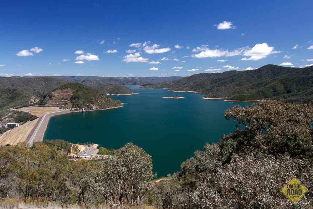
The town’s name has its origin in the days of early settlement in the district. A pastoral station purchased by Archibald Thorn in 1848 was named after his wife’s birthplace, the Eildon Hills, near Abbotsford in Scotland. Today, the name is synonymous with the dam that impounds Victoria’s largest water storage reservoir, Lake Eildon. The State Rivers and Water Supply Commission originally constructed the Sugarloaf Dam at the headwaters of the Goulburn and Delatite Rivers between 1915 and 1929 to provide irrigation water for what was then a vast uncultivated area on Victoria’s northern plains. This dam was modified in 1935 to increase its storage capacity but, proving inadequate to meet the needs of a growing agricultural industry in the Goulburn Valley, was replaced by the completion of the present dam wall downstream in 1955.
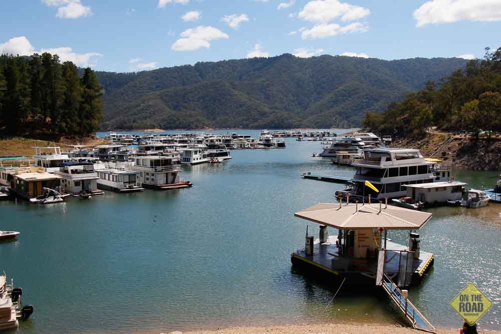
The new embankment dam wall was a marvel of civil engineering in its time. Rising to a height of 83 metres and comprising more than 10 million cubic metres of rock and earth fill, the wall impounds a reservoir with a capacity of 3.39 million megalitres and an area of 13,832 hectares. Lake Eildon is connected to the Melbourne metropolitan water supply and provides water for irrigation and the generation of electricity. From its early days, the lake has been a popular holiday destination for boating and fishing, but the fortunes of the local tourism industry have ebbed and flowed with the water levels. During the drought years of the mid-2000s, the lake dropped to a low of only 15% and the town suffered considerable economic hardship through inability to attract visitors. However, by 2011 the lake was back up to 82.5% and tourism is thriving once again, with an estimated 600 luxury houseboats gracing its waters, more than the number of houses in the town. And being a renowned playground for water sports, the aquatic needs of visitors and residents alike are now catered to by numerous boat ramps, a couple of harbours and the Eildon Boat Club and marina.
After visiting the dam to enjoy the glittering spectacle of the lake upstream and the scenic splendour of the town and Goulburn River pondage downstream, we drove up to the nearby Mt Pinninger Lookout (542m) for a 360-degree view of both while having morning tea. From here, we continued the morning’s tour along Jerusalem Creek Road to check out the various day-use locations and camping areas in the southern section of the national park. Although these latter were generally smaller and more fragmented than those in Fraser Block, they were handily configured for groups in a bushland setting, located within easy walking distance of the lake and served by a well-maintained boat ramp on Jerusalem Inlet.
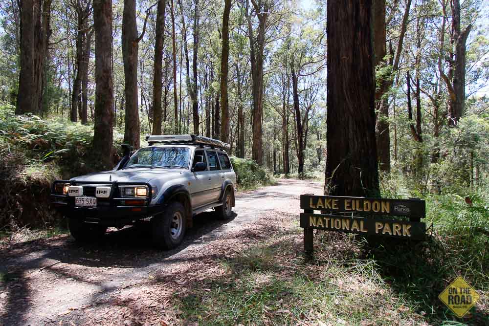
Jerusalem Block enjoys one advantage over Fraser Block in the form of a more extensive network of fourwheel driving tracks, most of them open during the summer months and embracing the park’s more remote valleys and peaks, as well as the O’Toole Flat camping area (no facilities). We didn’t venture very far afield here but, if our experience with the Wilson Creek Track is anything to go by, these tracks are rough and steep and would pose a serious challenge for the most enthusiastic offroader. (A broken winch cable around a tree at the top of one particularly gruesome section of Wilson Creek Track will give you a good idea of what to expect. This is not a track for the faint-hearted!) But travellers in this section of the park can still enjoy a fantastic drive along the easy Jerusalem Creek Road, following the watercourse through fern-filled old-growth forest to the Jamieson Rd, and a blacktop return loop skirting the park’s perimeter, a la Skyline Drive, to Eildon.
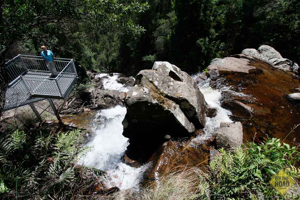
While descending this road, an interesting side-trip presents itself in the adjoining Rubicon State Forest – Snobs Creek Falls. At the Eildon end of Jamieson Rd, turn left on the Goulburn Valley Highway (towards Thornton) and follow this for about 2.5 km to the signposted access road to the falls. This climbs for 6km to a roadside pullout beside Snobs Creek and a short walk to the cascades and waterfall. If it’s pumping like it was when we were there, the detour is well worth the effort.
‘Diversity’ may not be the most inspiring adjective for a national park but it encapsulates the essential nature of Lake Eildon, which has it all – semi-remote camping with good facilities, bushwalking trails to suit a range of fitness levels, fourwheel drive tracks to challenge the most experienced driver and a glorious freshwater playground for a host of water-based activities. And it’s only two hours from Melbourne. What more could you ask for?
Location
Lake Eildon National Park is in the northern foothills of Victoria’s Central Highlands, about 150 km northeast of Melbourne and 100 km south of Benalla. The Lakeside and Candlebark camping areas are located about 18km east of Alexandra and the Jerusalem Creek camping area is 10km southeast of Eildon.
Access
Primary access to the Park is via the Maroondah Hwy from the south, the Goulburn Valley Hwy from the west and the Midland Link Hwy from the north. Important two-wheel drive access routes are Skyline Road and Fraser Park Rd (to Fraser block), Jerusalem Creek Road and Eildon-Jamieson Road (to Jerusalem and Jamieson blocks), and Goughs Bay Rd and Walsh Road (to Enterprise block). All except Walsh Rd are sealed.
When to Travel
Lake Eildon is a year-round destination but the best time to visit is during the summer months for the many water-based activities on the lake.
Fuel & Supplies
Alexandra, Eildon and Mansfield are the nearest towns for fuel and supplies. Within the park, at the entrance to the Fraser camping area, Fraser Store offers a limited range of convenience goods, such as ice, bread, milk, drinks, snacks and papers. It is open from 9am to 1pm every day from Boxing Day to the end of January, Labour Day and Easter holiday weekends.
Camping and facilities
The Park has a number of main camping grounds with facilities (in Fraser camping area and Jerusalem Creek), in addition to boat-based camping areas with toilets only (Mountaineer Creek, Coopers Point and Big River Arm), and a hunting camping area with no facilities at O’Toole Flat. All campsites are unpowered and facilities in the Fraser and Jerusalem Creek campgrounds include flushing toilets, hot showers, free gas barbecues, shelters, picnic areas and boat launching facilities. Rubbish bins are not provided (it’s a take in/take out rubbish policy) and no generators or chainsaws are allowed in the park.
Activities
Visitors to the park can enjoy bushwalking, mountain bike riding, four-wheel driving, trail-bike riding, water-based activities such as sailing, power boating, water-skiing, jet-skiing, canoeing and fishing. Deer hunting (without dogs) is permitted in season (winter) in some sections of the park. (No other hunting is allowed in the Park.)
Maps & guides
Excellent maps of the national park and camping areas and guides to the walking trails are produced by Vic Parks and available online at www.parks.vic.gov.au.
Contacts & information
Parks Victoria
P: (03) 8627 4700
E: info@parks.vic.gov.au
Lake Eildon Tourism
Alexandra Visitor Information Centre
Grant Street, Alexandra.
P: (03) 5772 1100
Eildon Tourist Visitor Information Centre
Opposite Eildon Shopping Village, Main Street.
P: (03) 5774 2909
Goulburn-Murray Water
P: 03 5770 8128 (for current lake information)