Is there a life up here?
“Blue Waterholes is very pretty in the right light”
“We dined on Peking Duck, gourmet meals having become passé”
“I was agog at the number of holidayers camped along Blowering Dam foreshore”
Dead Horse, dead trees, dead rocks, was there anything to savour?
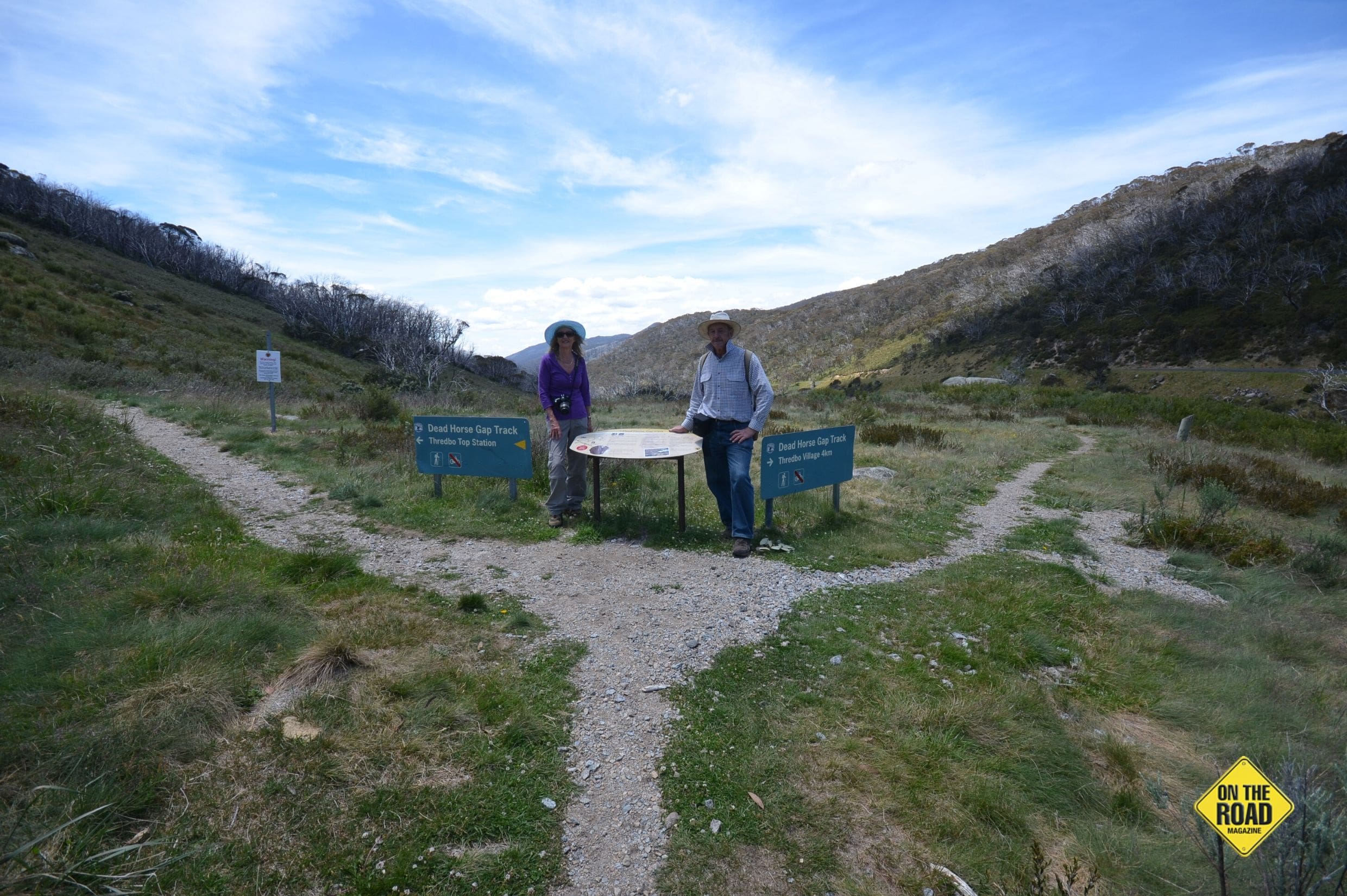
It was time for our last walk in the Snowys, to Dead Horse Gap from Crackenback and then down Thredbo Creek back to the motorhome which would take our total walking over four days to about 40 kilometres.
The healing powers of sleep will never be underestimated by Lorraine and me but we also knew this would be our last serious walk of the tour.
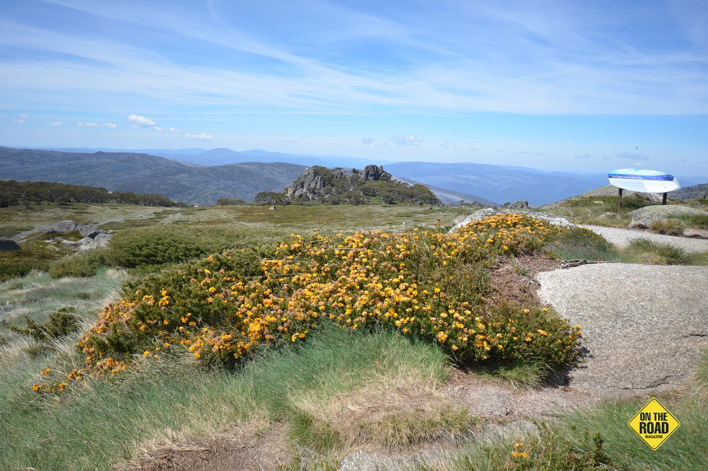
It was a chairlift ride to the top of Crackenback and then left instead of straight ahead to Kosciuszko. This took us initially past Ramshead, that rugged yet brittle clump of rocks that are much more dramatic than anything Kosciuszko had to offer. Set beyond the summer blooms they dominate the landscape, initially offering a stark contrast to the softness of the tiny petals. Further on high the gossamer cirrus clouds eked patterns out in an otherwise brilliant blue sky; we were feeling like privileged people, just how good was this.
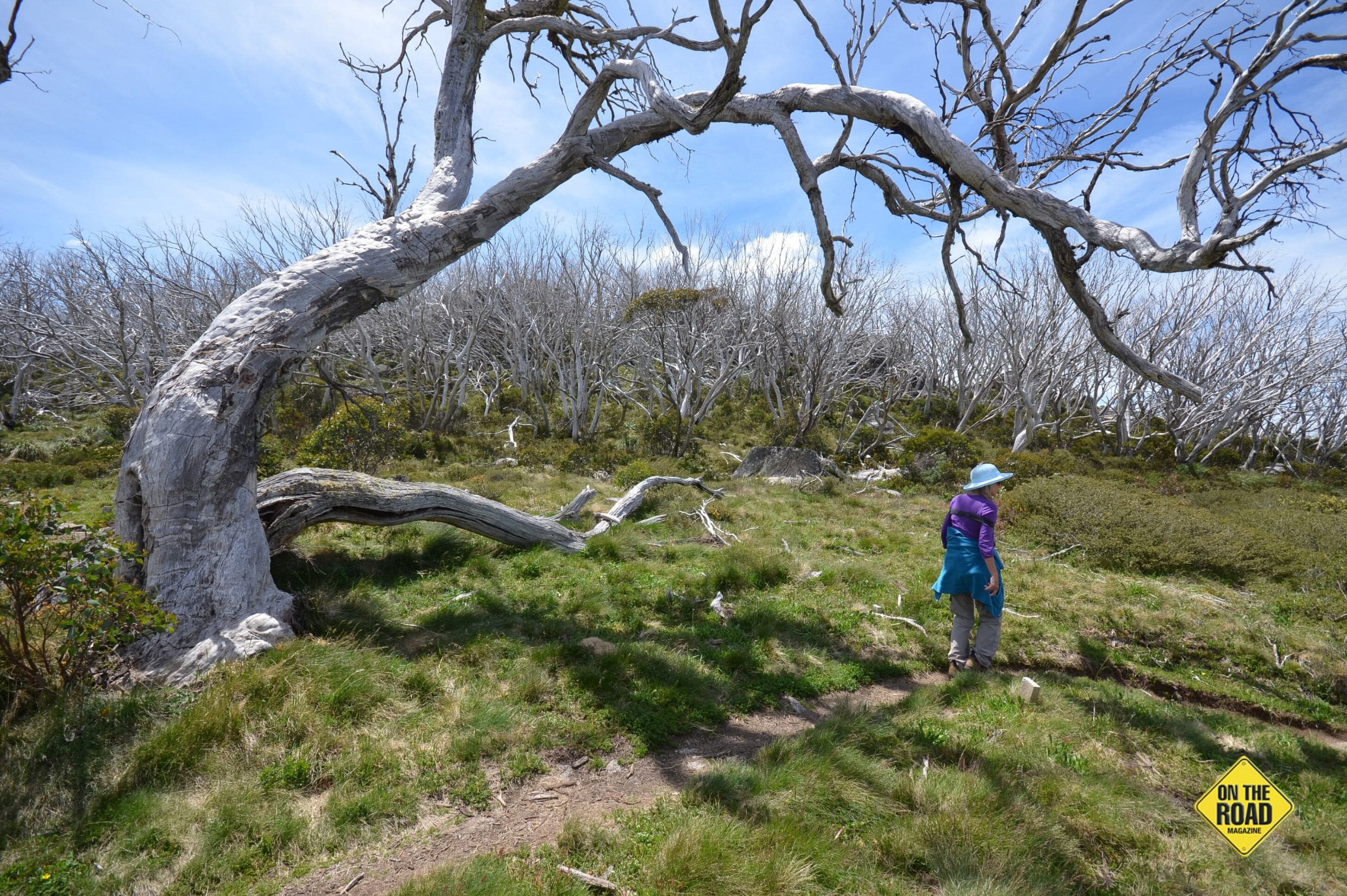
The track is just that; no broad boardwalk this day, simply a narrow rut through the flora heading off over the horizon and then descending through a surreal landscape of bleached snow gums darting off at all angles. Defoliated by the horrendous 2003 bushfires, the skeletal remains were so eye catching we stumbled now and then gaping at them. The lignotuber regrowth is different from other trees, they don’t sprout from the branches but from the base and, in this harsh climate, it’s a slow process. It was remarkable to see them in their thousands and know they would all fall over one day but so far stood erect, though lifeless.
Here and there shadows were cast eerily across the tussock grass while Spanish Moss clung precariously to some holes in the dead branches; an occasional fern cluster sheltered at the base of rock groups and here and there a trickle filtered its way to the master stream below. The wildflowers grabbed a spot wherever they could; the eggs and bacon native pea were more pronounced now while the delightful Kosciuszko Rose showed up here and there.
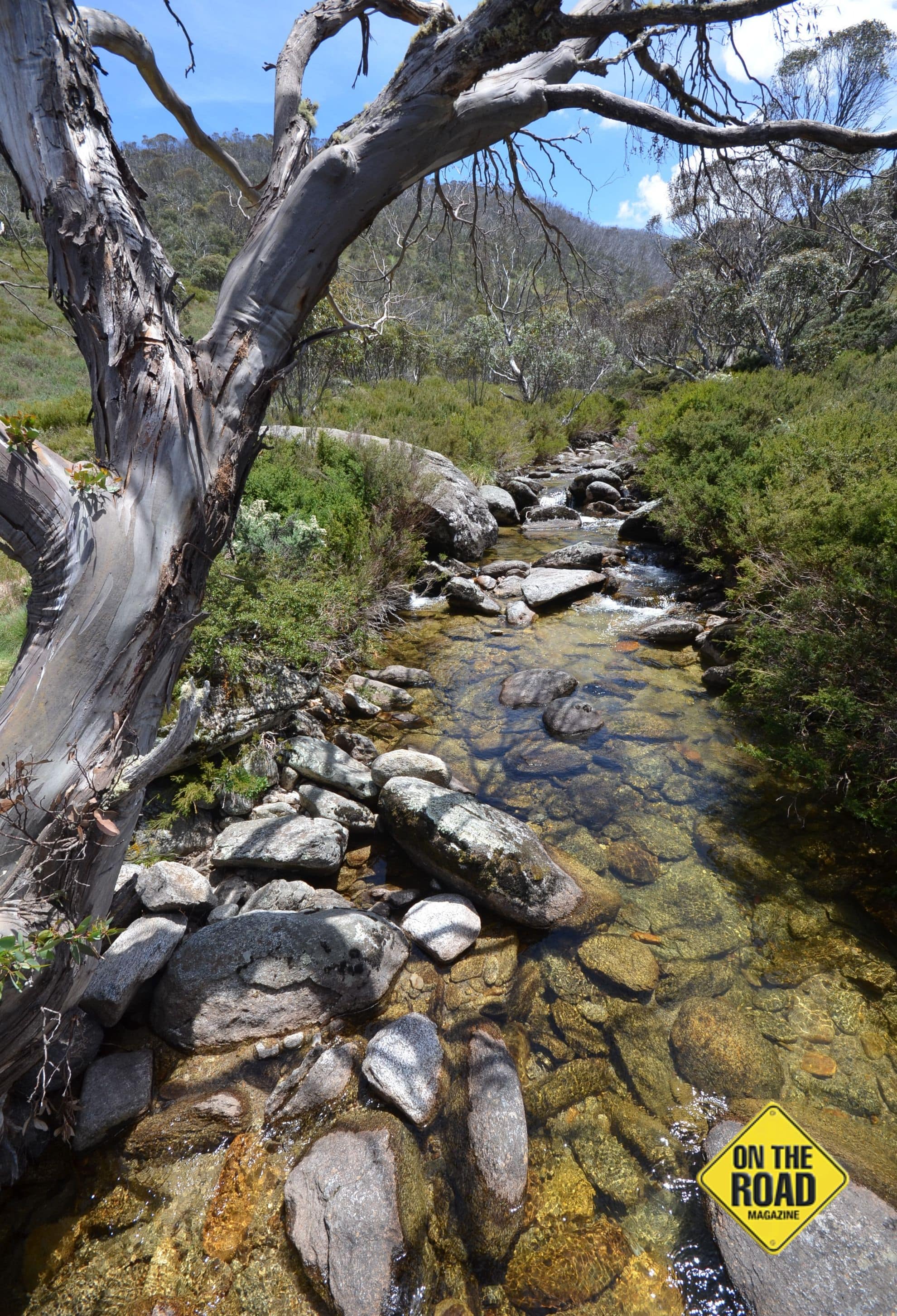
Then we started on the steps whereupon the fresh rushing waters of Thredbo Creek could be clearly heard about a kilometre away as we moved on, eagerly seeking a sight of the river.
We reached it and refilled the water bottle as I had done countless times over the previous days, the promise of pure mountain stream water too good to resist and everywhere it had been crystal clear, filtered water from the melting snows.
The Alpine Way was just across the other side and now motor vehicles contributed to the noise, though thankfully only occasionally, for it’s not a road for the fainthearted. Lorraine was keen to move further down the Thredbo Creek walk, for that was now the one we were on and, about 20 minutes later, we found a shady spot on some rocks in the river to have our repast. It was another memorable lunch among many we’d had this trip.
We pushed on after that, an anxiety to get out of the heat was also foremost in our minds. At least it was all gentle downhill and in what seemed no time at all we reached the extremity of the golf course, past sculptures, and cruised into the park where I couldn’t resist photographing yet more dragonflies.
At the start of the day I suggested we take the chair to the summit again and have a celebratory cuppa at Australia’s highest restaurant, the Eagles Nest, and that’s what we did, Lorraine ordering her first ever iced chocolate and we also had some of the nicest garlic prawns we’d ever tasted whilst admiring the extensive panorama over Thredbo.
It had been another wonderful day, what would tomorrow hold.
Nothing Like Variety
After our walk the previous day, we’d punted on, over Dead Horse Gap and plunged through the rainforest on the southern reaches of the Alpine Way. The tortuous road was time consuming and we weren’t sure where to stay after checking out Tom Groggin and Leatherbarrel Creek. Then we reached Geehi; suddenly it all became too easy. Here was a flat parking spot, toilets and the sound of a rushing river for ambience.
That night we dined in the motorhome on Peking Duck, gourmet meals having become passé with Lorraine on board. We pondered what the tent dwellers and motorcyclists were having, campers stretched at sensible intervals for as far as the eye could see just beyond us behind a copse of trees.
Next morning I was let off the leash and headed over the road down a paddock into the montane forest, seeking nature in its raw form but I came across little so I went back to Lorraine and we packed up to move on, heading first for the Murray 1 Power Station where Lorraine found a wealth of information about the scheme that she had known little about as it transpired.
Later in the day we would pass breathtaking scenery high in the mountains with dams right in the middle of steep gullies. The length and breadth of this world ranking engineering feat became ever more apparent as the day wore on. Tumut I Power Station for instance is 366 metres underground! In total there are 9 major stations and 16 major dams and they are activated during peak demand times. When off peak cuts in, the coal fired stations can’t switch off so the excess power they generate is used by the Snowy scheme to pump the water back up the hill. I learnt this when I used to call on the stations as a rep many years before.
Soon we were in Khancoban and had lunch in the rig, overlooking the dam below Murray 3 Power Station. Khancoban was a town built for the hydro scheme and it has managed to remain after just about all the workers left, though in places it’s a sorry remnant. Poor Lorraine came out of the “supermarket” traumatised at all the shelf space with so few goods.
We pushed on, climbing again until we came to Australia’s highest town, Cabramurra, the prettiest remnant of all with lupins everywhere. That now meant we’d drunk from the highest spring, eaten in the highest restaurant and been to the highest town, all firsts for Lorraine.
The scarring of the 2003 fires was something we’ll never forget though. 645,000 hectares were burnt in the park alone. Started by lightning strikes 57 blazes were lit and, though most were extinguished early, some got away and 5 people died, 541 homes were destroyed and an estimated 1.8 million hectares went up in smoke. The visible remnants of Australia’s largest recorded bushfire will remain for decades.
At the Snowy Mountains Highway intersection we headed west and then turned off onto Long Plain Road for 15kms and then turning again for another 8 kilometres on more dirt that I won’t ever bother with again to reach Blue Waterholes. It was a spot I’d wanted to return to in order to visit a gorge but by the time we reached the campsite Lorraine was on edge about some of the road (sorry, track) that we’d traversed.
Still, we had made it and ventured off late in the afternoon to see what there was and, after yet another double rock hopping creek exercise, walked down to Clark Gorge. It was impressive enough but, to get further required another four creek crossings and neither of us was about to tempt fate doing that; bearing in mind the water was freezing cold.
Still, the area was photogenic and the rest of the holiday campers were quiet all night which surprised us a little. One tent, though that is a thoroughly inadequate description, was set up for about 14 people and had everything including a kitchen sink.
Blue Waterholes is very pretty in the right light though the source of the water is uncertain because the karst formations have holes running through them everywhere. The word karst comes from the great limestone plateau in Slovenia.
We did a short walk down in the gorge again the next morning, this time with jet streams on high streaking the background above the rugged terrain.
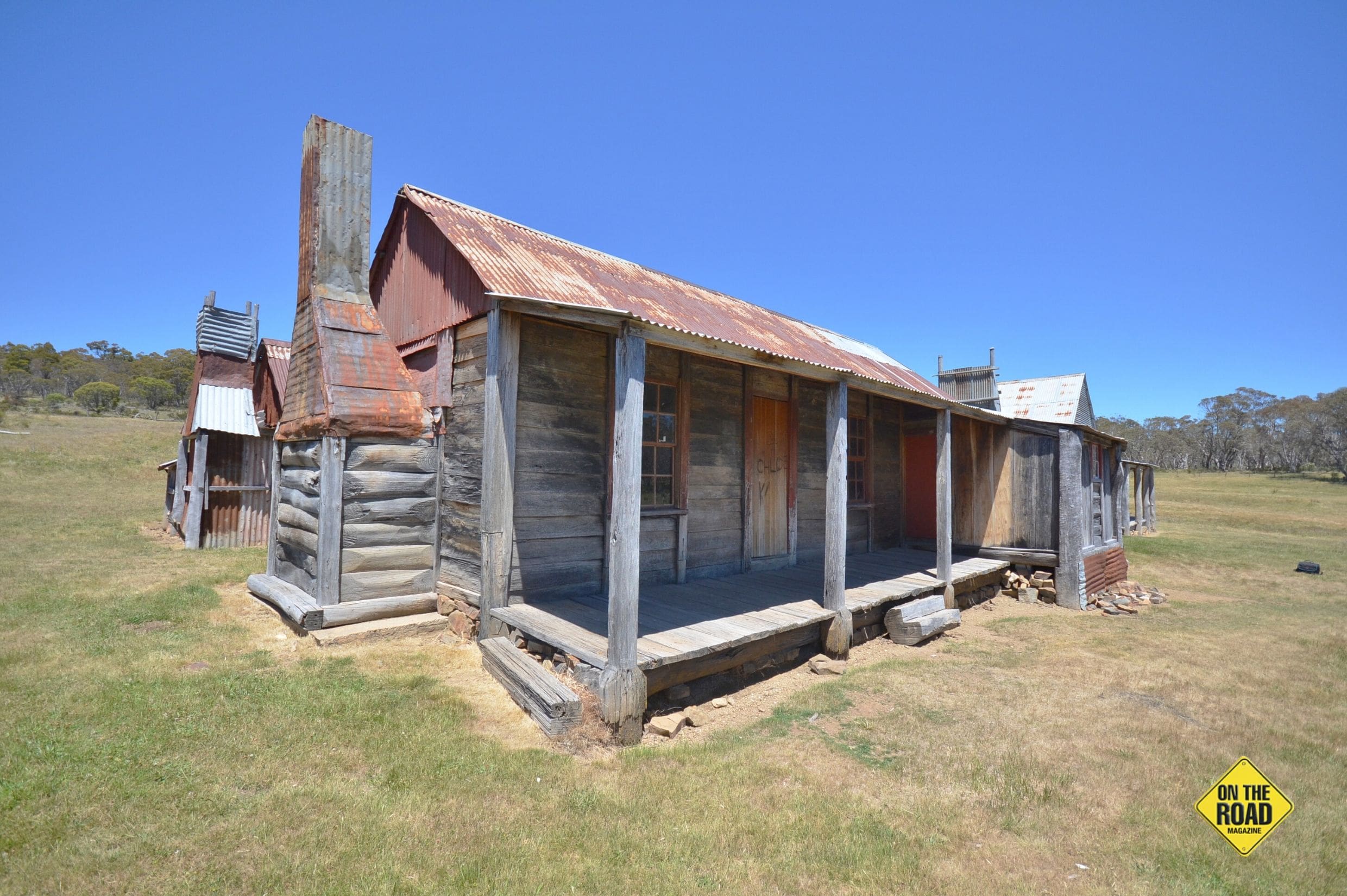
We departed after a brief photographic session and stopped en route to Yarrangobilly Caves at Coolamine Homestead, a rejuvenated collection of buildings dating from the late 19th century when this place was used for grazing, especially in summer. Newspaper clippings on one of the walls date back to 1892.
There’s even a cheese house that dates back to 1889; I guess keeping cheese cool up here wouldn’t be difficult for most of the year.
We pulled out and headed on down the road, my petrol pump slowly getting worse as the journey wore on and it was almost a relief to stop at the upper reaches of the Murrumbidgee River after passing some horse riders a little earlier with the engine spluttering away.
Still, we motored on to Yarrangobilly Caves and this was to be one of Lorraine’s favourite stops, I suspect not only on this trip but in all of Australia.
Time To Get The Cozzies On
It’s a one way loop road into Yarrangobilly, dropping off the plateau through open woodland down to an area where over 360 caves have been found – four are open to the public but it is interesting to note that nearly half have been discovered after the 2003 bushfires when more entrances were cleared of debris and opened up. It must be a great place for the spelios.
Lorraine had known there was a thermal pool here and to say she was keen to take the waters would be an understatement. The only catch is it’s over 700 metres to the pool and it’s seriously downhill; which naturally means a steep ascent after your dip.
Still, it’s well worthwhile with a constant temp of 27 degrees all year round and 100,000 litres of natural water gushing through daily it draws many a tourist. When we visited again on the second day it was astounding to see just how clear it was. In fact, I’ve seen lots of clear mountain streams but none with any more clarity than this pool. So, you may well wonder how this is so when algae and frogs live in it but, take my word, it’s amazing.
It was built in 1969 by prisoners, replacing the original wooden one constructed in 1890.
I also thought a visit to a cave would be good but could only get into Jillabenan, a cave I’d already visited twice. However, with Lorraine in tow it seemed like a better experience than my previous tours and she thoroughly enjoyed it as well.
Later, when we returned to the base at Yarrangobilly, we chose to try and see Jersey Cave the next day and duly booked in. We also chose to camp at the base in a lovely flat park with shady mature gum trees. That worked out well until, around dinner time, a friendly ranger came up and basically told us there was no overnight camping so we had to move out.
Normally that wouldn’t have been a major problem but the petrol pump was seriously faulty by this time and it took us around an hour to do the 7 km ascent up the hill to the highway with the motor constantly cutting out. Frayed nerves eased a little when we hit the highway and headed west to Yarrangobilly (the place, as it says on the map).
Here was an open campsite by a stream and a new National Parks building, not quite finished. Despite the chronic fuel problem we plunged back down the dirt to Yarrangobilly Caves next day and, before our salutary dip in the pool, we walked to the Glory Hole, the original settlement here. Poignant reminders of the past still peeped through the vegetation but the signs told the full story of hardship.
Henry Harris was a butcher who emigrated in 1857, followed by his wife Harriet and three children a year later. When gold was discovered at Kiandra they moved there and plied his trade after the birth of their fourth child in Sydney and, along with another three born in the Snowys, they all lived to adulthood.
They settled on acreage at the Glory Hole and their house evolved to a 5 bedroom affair over the years. Henry died in 1898, aged 77, in unusual circumstances; apparently, after being frostbitten while riding to and from Yaouk, he succumbed to cellulitis. Harriet died six years later from natural causes.
The house was abandoned when the Harrises moved on in 1910 and was used by trappers and prospectors until vandals and then bushfires eventually destroyed it entirely.
Still, it was interesting, and by the time we finished our pool antics we’d already had enough entertainment for the day. Jersey Cave, however, put everything else in the shade.
I’ve been in caves around the world but this, square metre for square metre, has more and more varied formations than any other I’d been to and in such a relatively small area. At only 185 metres long and with 217 steps it’s not huge but you don’t even notice, so intricate are the displays. Hard to believe that you can spend 1 ½ hours in a place so small and not get bored.
It had shawls, helictites (formations going in random directions that even Microsoft haven’t heard of), flowstones in varying colours due to iron oxide and bushfire ash seeping through, straws, cave pearls (clusters in the water) and all the other usual suspects.
It was a sign of the times that the ranger told us that more than one child has come down there thinking it was a Disney type attraction expecting things to pop out and that it was all made of plastic. Hopefully they are now better educated.
After the tour the motorhome managed the trip up the hill a lot better this time and we headed west towards Tumut. Along the way I was agog at the number of holidayers camped along Blowering Dam foreshore. Motorboats and kayaks were de rigueur as we passed where once a world record had been set by Ken Warby in his jet powered boat at 512 kph. Incredibly, it still stands today.
We camped the night at Tumut, but that’s the start of another story.
BREAK OUT BOX 1: Camping at Yarrangobilly is free and there’s a composting toilet available. The campsite is NOT actually at the caves but on the main highway.
BREAK OUT BOX 2: Campground at Blue Waterholes is free, as are others nearby such as Cooleman Mountain, Cooinbil and Long Plain. Blue Waterholes also has pit toilet. Bear in mind that these are closed much of the winter and park entry fees apply.
BREAK OUT BOX 3: The road into Yarrangobilly is winding dirt and not suitable for caravan towing. Phone number is (02) 6454 9597, if you want more details about the caves or to book ahead for Jersey Cave.