A popular destination for camping, bushwalking, fishing, surfing and scuba diving
Yorke Peninsula’s southern shores have been described as the “high-energy coast”, as much for the powerful Southern Ocean swells that hurl themselves against its rocky headlands and beaches as for the adrenalin-pumping recreational opportunities to be enjoyed here, especially at Innes National Park. As many as 200,000 visitors are drawn to the park each year to walk the spectacular cliff top trails, surf the ocean beaches, fish from rocks and jetties or scuba dive in its pristine waters. The attraction for us was to follow a heritage shipwreck trail that began 4000 km to the east on Victoria’s Gippsland coast and continued here along the edge of the Investigator Strait, where treacherous reefs and violent, unpredictable weather have taken a terrible toll in vessels and human lives.
We entered Yorke Peninsula on a sun-filled autumn day under a cerulean sky streaked with high-altitude cirrus. The waters of Gulf St Vincent sparkled as we tootled along the peninsula’s eastern flank to Edithburgh. Here we left the Yorke Highway in favour of a scenic drive that clung to the coast along a limestone gravel road the rest of the way to the town of Marion Bay, the gateway to Innes National Park.
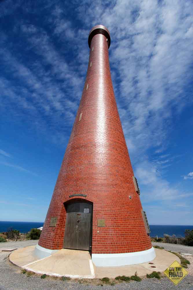
Not only was this route blessed by glittering ocean views but it led to a couple of interesting waypoints worthy of inspection. The first of these was Wattle Point Wind Farm, where 55 gleaming white turbine towers projected from pancake-flat wheat fields, a location swept by winds of average speed among the highest on mainland Australia. When it was officially opened in 2005 it was Australia’s largest wind farm at 91 megawatts. A few kilometres further on we came to the route’s second point of interest, the lighthouse on Troubridge Hill. This 32-metre structure overlooks the treacherous Troubridge Shoal and nearby Marion Reef, which has claimed numerous vessels, including the 3600-ton steamship Clan Ranald. Built in 1980 from custom-made, wedge-shaped red clay bricks, the tower’s unusual window-less chimney shape was designed to resist earthquakes and high winds and attracted a special award from the South Australia Clay Brick Association.
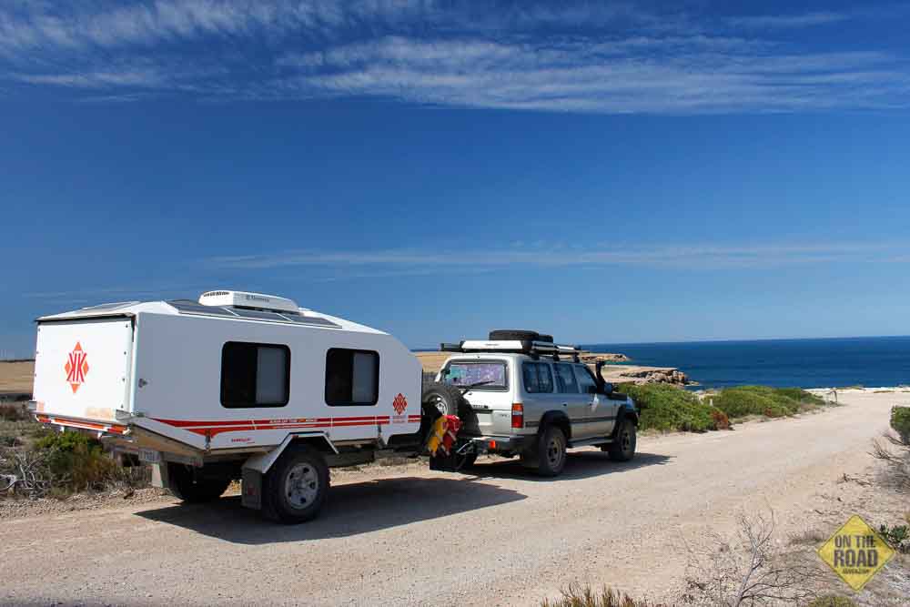
For another 60 km the scenic route skirted a series of bays and headlands before delivering us at Marion Bay. With surf and swimming beaches and excellent fishing available, this rustic outpost is a popular holiday destination and makes a perfect base for exploring the national park. There are many accommodation options here for travellers and we opted for a powered site at the Marion Bay Caravan Park, with a patch of recycled synthetic tennis court for the annex, shaded by a large tree that filled each morning and evening with scores of raucous roseate cockatoos. The facilities were quite reasonable for a council-run operation and had been augmented by some newly constructed ensuite-style amenities. This would do us very nicely as our base for the next few days.
On our first day in residence we learned that Yorke Peninsula’s location and general orientation – surrounded on three sides by ocean and projecting from the mainland in a generally southwest direction – expose it to some pretty fickle elements and strong winds; the blustery, rain-speckled conditions we woke to were very different from those we had enjoyed on our drive here. So, deferring our foray into Innes, we filled the day by touring the local precinct and boning up on some essential background reading.
The traditional custodians of Yorke Peninsula are the Narungga people, a group comprised of four clans – the Nantuwaru, Windera, Wari and Dilpa – who lived mainly along the coast. Innes National Park contains a number of culturally significant sites related to their Ngarna creation dreaming, after which many features of the park are named, as well as several locations that evidence the people’s occupation over thousands of years.
Matthew Flinders charted the coastline in 1802 but the peninsula remained largely unsettled until 1847 when colonists began clearing land for crops and grazing sheep. Spring-fed wells were established at Pondalowie Bay and Browns Beach for the benefit of sheep stations at Cape Spencer, Carribie and Stone Hut during the 1860s. Farming in what is now the national park struggled throughout the 19th century with poor yields due to the harsh coastal environment and soil infertility. A significant milestone in the settlement of the southern districts occurred in 1883 with the construction of a telephone landline from Yorketown to Cape Spencer via Cable Bay.
The area’s unique geology also attracted mining to the district. When sea levels fell to their present levels about 7,000 years ago dune systems developed along the coastal fringe and stranded a number of lakes inland. These lakes became evaporation salinas in which calcium carbonates and sulphates crystallised to form large deposits of gypsum. Interestingly, these same lakes fostered the evolution of stromatolites and the national park is one of only three places in the world where these “life forms” are known to exist.
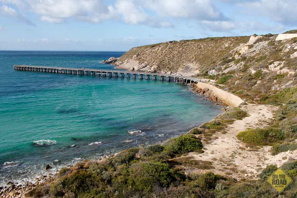
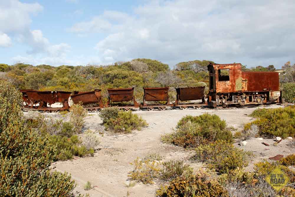
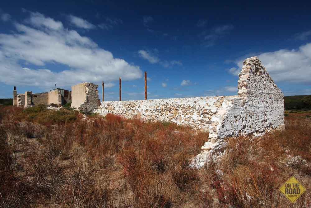
In 1889, the Australian Gypsum and Whiting Company began mining gypsum at Marion Lake, near the bay that shares the name, developing infrastructure that included the first stage of the Marion Bay jetty and a timber rail track (later steel) for two steam locomotives and small side-tipping trucks. In 1913, the Permasite Company of Melbourne (owned by G Bell, A Stenhouse and William Innes) began mining operations at Inneston Lake and built a 200-metre jetty to enable ships to berth and load the bagged gypsum for transport to markets on the mainland and overseas.
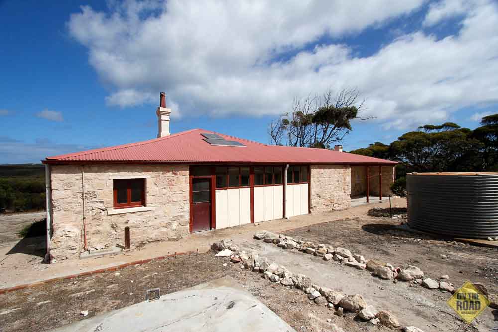
By the early 1900s a community of approximately 150 people was flourishing at Inneston Lake, with a school, butcher, baker, bank, post office and recreational facilities that included a tennis court and cricket pitch. Dances in the public hall were reputedly popular, but formal, affairs – men were not admitted without a tie, ladies were expected to wear gloves and alcohol was strictly forbidden. Substantial homes with commanding views of the mine site and township were built for the Mine Manager and the Mine Engineer, and electricity was introduced to numerous stone buildings.
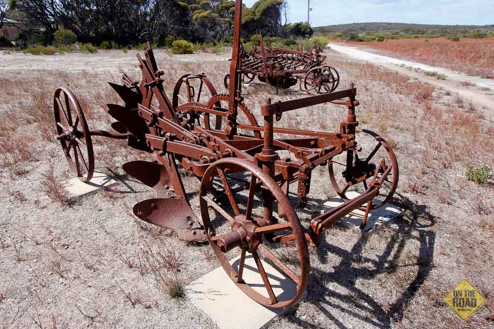
In 1927 Inneston was officially proclaimed a town but its fortunes were short-lived. With the advent of the Great Depression in 1930 mining here became uneconomical, the factories closed and Inneston was abandoned. Until recently, small-scale commercial mining continued on several lakes outside the national park and, between 1905 and 1973, 6 million tons of gypsum were mined from the local region. Today, the park features extensive remnants of this mining history, including heritage sites at Inneston and Stenhouse Bay, and some of the buildings at the Inneston precinct have been restored and are available to hire for accommodation.
By day two of our stay, the sullen weather had abated and we were eager to enjoy some of the national park’s “high-energy” attractions, starting with the Lookout Walk at Stenhouse Bay. Until the late 1960s, Stenhouse Bay was a busy harbour town and the hub of the booming gypsum industry, with a resident community numbering about 500. Today, little remains of this once thriving town except for a smattering of preserved buildings, including the old hall (available to hire for accommodation), the jetty and the faintest hint of abandoned rail lines and infrastructure among the regenerating bush.
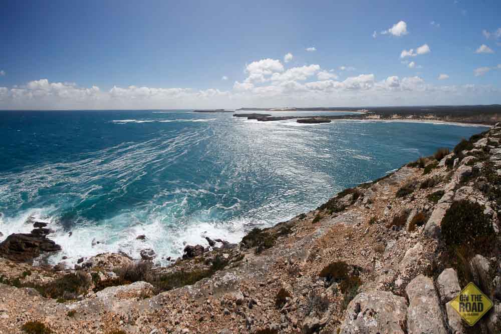
A brisk southerly wind greeted us as we stepped from the car and began the climb to the top of the cliff overlooking the bay. At the summit was a panoramic view across Investigator Strait (named by Matthew Flinders in honour of his ship) and the rocky granite coastline stretching away to the west. The walking trail traced the cliff line in that direction along a buff white gravel track hedged on either side by a variety of crouching heath-like plants and succulents, stunted and pruned by salt spray and ceaseless wind. Interpretive signs informed walkers about the landscape, both natural and human, and the wealth of maritime history that pervades the south coast of Yorke Peninsula.
At the headland, we encountered two graves. One of them was that of Dao Thanh Le, a 27-year-old Vietnamese seaman on SS Notue, killed when struck by a sack of coal. As a Buddhist, he could not be buried at sea and when the ship’s master made arrangements to do so, Thanh’s coreligionist shipmates threatened to mutiny. So, on 25 March 1940, the ship called at Stenhouse Bay where a local carpenter made a coffin and Thanh was buried with due ceremony.
The other grave, visible from the headland but submerged in 9 metres of water, was the last resting place of the ill-fated sailing ship Hougomont. In its first 24 years of service, this 2400-ton steel-hulled vessel ran aground twice, was posted as missing once and was partially dismasted in another incident. After a lay up of three years she was again dismasted, this time off the Portuguese coast while sailing to Melbourne. On the night of 20 April 1932, the Hougomont was 111 days out from London bound for Port Lincoln to load a cargo of wheat, when it was struck by a fierce gale about 850 km southwest of Kangaroo Island. Within minutes, winds of 100 km/h tore away the vessel’s masts and rigging, leaving it wallowing in heavy seas. Sailing under jury rig, the Hougomont limped for a further 18 days to anchorage off Port Adelaide, where its owners determined that the expense to repair the vessel was greater than its value and decided to scrap it. After being stripped of its fittings, the Hougomont was sold to the Waratah Gypsum Company and towed to Stenhouse Bay where, on 8 January 1933, it was positioned southwest of the jetty and scuttled to provide a breakwater for vessels in the bay.
The Hougomont is just one of many ships featured in the ‘Investigator Strait Maritime Heritage Trail’. Between 1849 and 1982, 26 vessels have been wrecked in the waters of Investigator Strait – more than half of them along the park’s coastline between West Cape and Marion Bay – with the loss of more than 70 lives. Vessels of all types and sizes are among the wrecks, ranging from small wooden fishing cutters to leviathan steel-hulled steamships, representing the whole range of social, industrial and maritime activities that have been important to the development of South Australia. Over time, these submerged hulks have become eerily beautiful habitats for a diverse range of marine life, attracting divers from around the world. For landlubbers, seven interpretive signs have been erected along the exposed, storm-lashed coastline of the lower Yorke Peninsula, above cliffs and sandy beaches that overlook the final resting place of the wrecks they describe. We would see several such signs on our journey through the park this day.
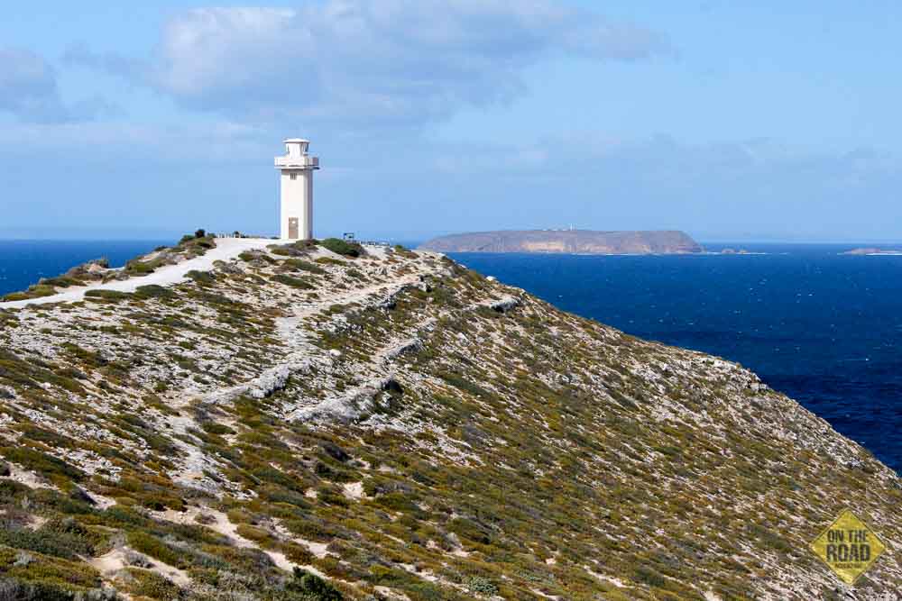
Returning to the car, we followed the park’s main road west past Chinaman’s Beach, a popular surfing location noted for its powerful, high quality reef break (suitable for skilled surfers only), to our next stop at Cape Spencer. Matthew Flinders named this headland after Earl George Spencer, one of the Lords Commissioners of the Admiralty in office at the time of planning Flinders’ expedition to ‘Terra Australis’. It is the most southerly point on the Yorke Peninsula and, since 1950, has been the site of an operating navigation aid, contained in an octagonal edifice with a concrete façade that sparkles with large chips of limestone. This impressive structure is perched on a narrow headland surrounded by a wave-swept rock platform with spectacular views of the coastline in both directions and across to the Althorpe Islands.
These islands feature significantly in the heritage trail as being the site of six wrecks, all but one of which occurred, ironically, after a lighthouse began operation on the largest island in 1879. Most of these were small fishing cutters, which came to grief while sheltering from violent storms. The largest shipwreck was that of the S.S. Pareora and it is a sadly poignant thing to know her story while gazing at the scene of her demise from the headland at Cape Spencer.
On 16 September 1919, the 355-ton steamer Pareora left Port Pirie with a cargo of zinc bound for Hobart. Shortly after departing, the steamer ran aground and was stuck fast on a sand bank for twelve hours. This did not augur well for the journey and one crewman was heard to remark that “I won’t be satisfied until we pass the Althorpes”. Alas, in heavy seas two days later the Pareora struck Althorpe’s rocks and was quickly broken up by tremendous waves. Unable to release the lifeboats, the men either jumped or were washed overboard. Alerted by their cries for help, the heroic crew of the cutter Zephyr, which was sheltering nearby, plucked seven survivors from the perilous seas, but the master and ten of the Pareora’s crew were drowned. A cross erected on Althorpe Island marks their graves.
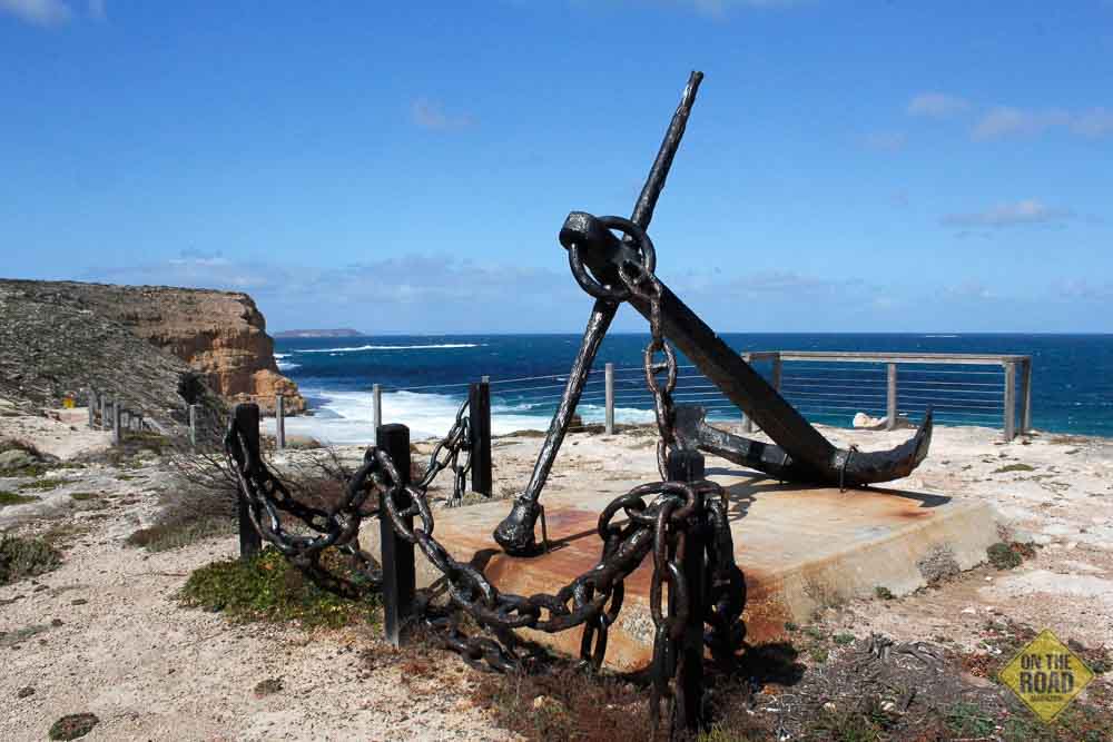
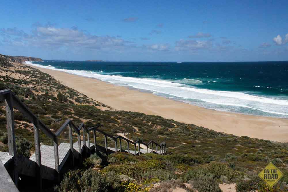
A short drive further west brought us to Ethel Beach and another chapter in the maritime history of this amazing coast, this the most bizarre so far. Alighting at the car park, travellers confront yet another panoramic view of the national park’s rocky headlands and beautiful sandy beaches, the squat form of Althorpe Island crouching menacingly just offshore. Atop the cliff above the beach is a memorial comprising a ship’s anchor on a concrete plinth and cordoned by its chain, all the metal painted in black enamel in sombre eulogy to the lives and vessels lost along the Investigator Strait. Beyond the guard rail lies the golden swathe of Ethel Beach far below, braced at each end by sheer orange ramparts projecting almost to the surf, like book ends framing the story that unfolded on this sandy page, punctuated by the rusting iron ribs of a keel partly seen above the tide line.
On 2 January 1904 the 711-ton iron-hulled barque Ethel, bound for Port Adelaide, entered Investigator Strait in poor visibility churned up by gale force southwesterly squalls. A misdirected course cast the vessel onto a reef near Cape Spencer, damaging its rudder. Drifting at the mercy of wind and waves, the Ethel was driven broadside onto this small beach northwest of Reef Head, stranded but largely undamaged. At daylight a passing vessel, the S.S. Ferret, arrived on the scene to render assistance and all but one of the crew was rescued. During a salvage attempt several months later, as the Ethel was being dragged into deeper water, the towlines parted during a sudden storm and the Ethel was thrown back onto the beach, with a broken keel, where she has lain ever since.
Ironically, S.S. Ferret was to meet the same fate on the same beach 16 years later. The 460-ton steamship was built in Glasgow in 1871 for the Scottish coastal trade and found its way into Australian waters after having been stolen by confidence tricksters in 1880. It arrived at Port Phillip in Victoria under the false name of S.S. India, where it was recognised by a newly arrived Scottish policeman and seized in dramatic circumstances. Restored to its original name it was purchased in 1883 by the Adelaide Steamship Company, which operated the vessel on the Yorke Peninsula for another 37 years. On 13 November 1920 the Ferret left Port Adelaide with a cargo of beer, wine, whiskey, timber, petrol, engines, bricks, iron and other supplies for Yorke’s coastal settlements. At about 3:00am the following morning the Ferret became enveloped in thick fog near Althorpe Island. In the mistaken belief that she had passed clear of the island and Cape Spencer, a change of course steered her into breakers, which drove her onto the beach 200 metres from the wreck of the Ethel. Although all 22 crew made it safely to shore, the vessel could not be salvaged and has since been pounded to scrap by the relentless surf.
Just around the next headland to the northwest, lay West Cape Beach, an enormous stretch of golden sand leading to the most westerly point on Yorke Peninsula. This beach is renowned for its excellent surfing and fishing opportunities, although conditions can be made dangerous and unpredictable by rips, strong currents and tides. The cape is a bleak limestone plateau overlaid with stunted vegetation that has been bent and bonsai-ed by incessant gales. It is surmounted by the West Cape Lighthouse (1980), a gleaming stainless steel structure that more resembles a giant Dalek than a navigation aid, standing proudly, if somewhat incongruously, 67 metres above the ocean at the entrance to Spencer Gulf. A walking track around the headland affords a 360-degree view of the “high-energy coast”, made manifest here by indigo swells rolling in off the Southern Ocean and foaming brilliant white across the rocky platform skirting the cape.
We would have liked to continue our westward journey through the park to Pondalowie Bay (another popular surfing venue), Royston Head (for more grand views) and the Chain of Lakes, but the afternoon was waning and we wanted to use the remaining light to inspect the Inneston historic precinct. This we did, for about an hour, on our way back to camp and were well rewarded by a myriad photogenic scenes that included Inneston Lake’s limpid saline waters, an eerily quiet village of crumbling limestone masonry and rusting iron relics that were once the engines of industry – in all, a fitting finale to our investigation of the Innes National Park.
Location
Innes National Park is located on the southwest tip of Yorke Peninsula, 300km by road west of Adelaide, via Port Wakefield, Ardrossan and Marion Bay.
Access
Several main roads run the length of Yorke Peninsula to the national park and a minor unsealed road provides an alternate route along the south coast from Edithburgh to Marion Bay. This latter is narrow and rough in places but generally suitable for conventional vehicles. Within the park a good sealed road runs from the visitors centre at Stenhouse Bay to most of the major attractions as far as Pondalowie Surf Break carpark. An unsealed road continues to Browns Beach campground near the park’s northern boundary and unsealed side roads connect with Cape Spencer and Inneston Historic Township, all of which are suitable for two-wheel drive vehicles. Entry fees apply to all vehicles entering the park.
Best time to travel
Innes National Park is a year round destination although the ocean will be warmer during the summer months for surfing, swimming and diving.
Attractions
Mining and maritime history, Inneston historic village, shipwrecks, lighthouses and stromatolites.
Activities
Bushwalking, wildlife viewing, birdwatching, photography, fishing, surfing and scuba diving.
Fuel and supplies
Food, water, fuel, basic supplies and meals are available from Innes Park Trading Post and Rhino’s Tavern at Stenhouse Bay and at Marion Bay just outside the park.
Camping and facilities
There are 7 campgrounds within the national park. Those at Stenhouse Bay and Pondalowie Bay can accommodate caravans and camper trailers and have toilets and gas BBQs. The other campgrounds are better suited to tents and have toilets only.
Campers need to be self-sufficient and carry adequate supplies of water. Camping fees are payable in addition to the park entry fee.
Other accommodation
The national park offers alternative accommodation in Shepherd’s Hut (a single-room, unpowered stone cottage with bunk beds), Stenhouse Bay Hall (with bunk beds, showers, recreation area and kitchen) and at Inneston Heritage Precinct (self-contained lodges variously appointed with showers, toilets, kitchens and gas or combustion heating).
Marion Bay Caravan Park is only 5km from the park and offers a wide range of accommodation from self-contained cabins to caravan sites and powered/unpowered camping. Facilities include: a camp kitchen, barbecue, laundry, gas refills and internet wifi.
Contacts
Department of Environment and Natural Resources
NPWSA Yorke District Office
P: (08) 8854 3200
E: DENRInnesNationalPark@sa.gov.au
W: www.environment.sa.gov.au/parks
Marion Bay Caravan Park
17 Willyama Drive, Marion Bay
P: (08) 8854 4094
District Council of Yorke Peninsula, Warooka
P: (08) 8854 5055